October 26, 2004
GIS in classroom presentation
The classroom presentation is a device for the State to show its relationship to the natural world and the pre-existing order of things in a good light. A cross between Shell and Guns Ltd. http://www.shell.com/ http://www.gunns.com.au/
One opportunity to quickly establish the theme of networking is to move between Aboriginal rock carvings in the sanctuary and futuristic GIS (Geographic Information Systems). Integrating this in with the establishment shots of the bush, State and city could be very interesting. The sophistication of Aboriginal carvings (e.g. how the animal shapes reflect the relative positioning of key landmarks like waterholes and other carvings) is new information to most people and a good hook.
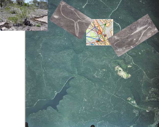
Carvings are from the Calga Springs sanctuary outside Gosford.
The GIS display is part of a UK prototype "post-it" service - Urban Tapestries http://www.proboscis.org.uk/urbantapestries/prototype.html
Aerial photography from http://www.lpi.nsw.gov.au/airview/
MORE RESEARCH
======================================
petroglyph
petro = rock glyph =carving
The meanings of most of these petroglyph designs remain unknown.
http://www.hausarbeiten.de/faecher/hausarbeit/eni/16622.html
In Europe and Africa the style was largely naturalistic, while in Australia and the Americas designs were more often symbolic and geometric, and sometimes approached a primitive form of writing.
http://www.encyclopedia.com/html/r1/rockcarv.asp
D. S. Davidson, Aboriginal Australian and Tasmanian Rock Carvings and Paintings (1936)
http://www.viewzone.com/tablerock.html
Hypothesis of a global ancient alphabet in Aus and elsewhere
http://www.adelaidegrid.warp0.com/photo3.html
Whitley was the first American archeologist to do a dissertation interpreting rock carvings (the technical term is petroglyphs; rock paintings are pictographs). There has been a tendency among archeologists to regard the study of ritual and belief as less scientific and less relevant than the study of technology and subsistence. "Its that bumper sticker: He who dies with the most toys wins," Whitley says. "Which is, to me, a very shallow, materialistic view of human culture."
To illustrate his point, Whitley gives the example of Australian Aborigines. "You can take a line from the center of Australia out to the coast, and you can plot on that line a series of different aboriginal cultures. And if you look at the complexity of their kinship system and the complexity of their technology and tools, what you see is a perfect inverse relationship." Coastal groups have a complex technology and tend to use a lot of tools. In the middle of Australia, its more like it is in the Cosos. "Those guys are running around near to buck naked, surviving only on their wits, yet they have this kinship system that is mind-bogglingly complex. And it structures every aspect of their social life.
http://www.mc.maricopa.edu/dept/d10/asb/anthro2003/readings/altered_states.html
Now what is more important, this complex cognitive mental construct or the kind of tools these folks made?"
Ogleby, Clifford L., Digital Technology in the Documentation of Rock Art, 2nd AURA Congress, Cairns, Australia,
September, 1992.
Clear pictures - maybe fake...
http://artshack.tripod.com/aboriginalrockart.html
Australian Rock Art Research Association, Inc.
http://mc2.vicnet.net.au/home/aura/web/index.html
State Agency support
No databases are utilized regularly, although some projects in Australia have incorporated GIS into regions that include rock art sites. At least two state agencies in Australia, the News South Wales National Parks and Wildlife Services and the Australian Institute for Aboriginal and Torres Island Studies, sporadically use a database called 'Minarch'
13. Linking places: Constructing an Aboriginal social landscape using Arcview
Claudia Zipfel (Runner up Aus Archaeological Assoc. Conference Poster Prize
School of Historical and European Studies, La Trobe University (czipfel@students.latrobe.edu.au)
Based on a 2002 Honours research project this poster details the methodology developed for the construction of social landscapes in the GIS program ArcView. The project aimed firstly at constructing the context of the relationship between an Aboriginal community in the Wimmera and Mallee regions of Victoria and the archaeological remains found in its area today. Secondly, it examined the suitability of ArcView to construct and represent this context, ie. the social landscapes....
ArcView was found to be very useful for social landscape representations. It enables a visual and textual exploration of the interconnectedness of places, paths and inhabitants in space and through time. GIS seem particularly well suited for such a purpose as they have the potential to raise an awareness of the different and shared nature of social landscapes of archaeologists, Aboriginal and non-Aboriginal communities.
http://car.anu.edu.au/AAA_poster_session.html
AURA
P.O. Box 216
Caulfield South, Vic. 3162
Australia
auraweb@hotmail.com
Australian Archaeological Association Inc.
Archaeology A14
University of Sydney
NSW 2006
AUSTRALIA
Email:
mailbag@australianarchaeology.com
Telephone:
+61 (2) 9351 7412
Facsimile:
+61 (2) 9351 5712
Ausarch-l
http://mailman.anu.edu.au/mailman/listinfo/ausarch-l